Country Profile

Bahrain

of Iran

Iraq

Kuwait

Oman

Qatar

Saudi Arabia

Emirates
Kingdom of Bahrain
Geography. Bahrain is a generally flat and arid archipelago. The land consist mostly of low desert plain rising gently to a low central escarpment with the highest point the 134 m (440 ft) Mountain of Smoke (Jabal ad Dukhan). Bahrain has a total area of 665 km2 (257 sq mi) but due to land reclamation, the area increased to 780 km2 (300 sq mi). Bahrain’s largest islands are Bahrain Island, the Hawar Islands, Muharraq Island, Umm an Nasan, and Sitra. Bahrain has mild winters and very hot, humid summers. The country’s natural resources include large quantities of oil and natural gas as well as fish in the offshore waters. Arable land constitutes only 2.82% of the total area.
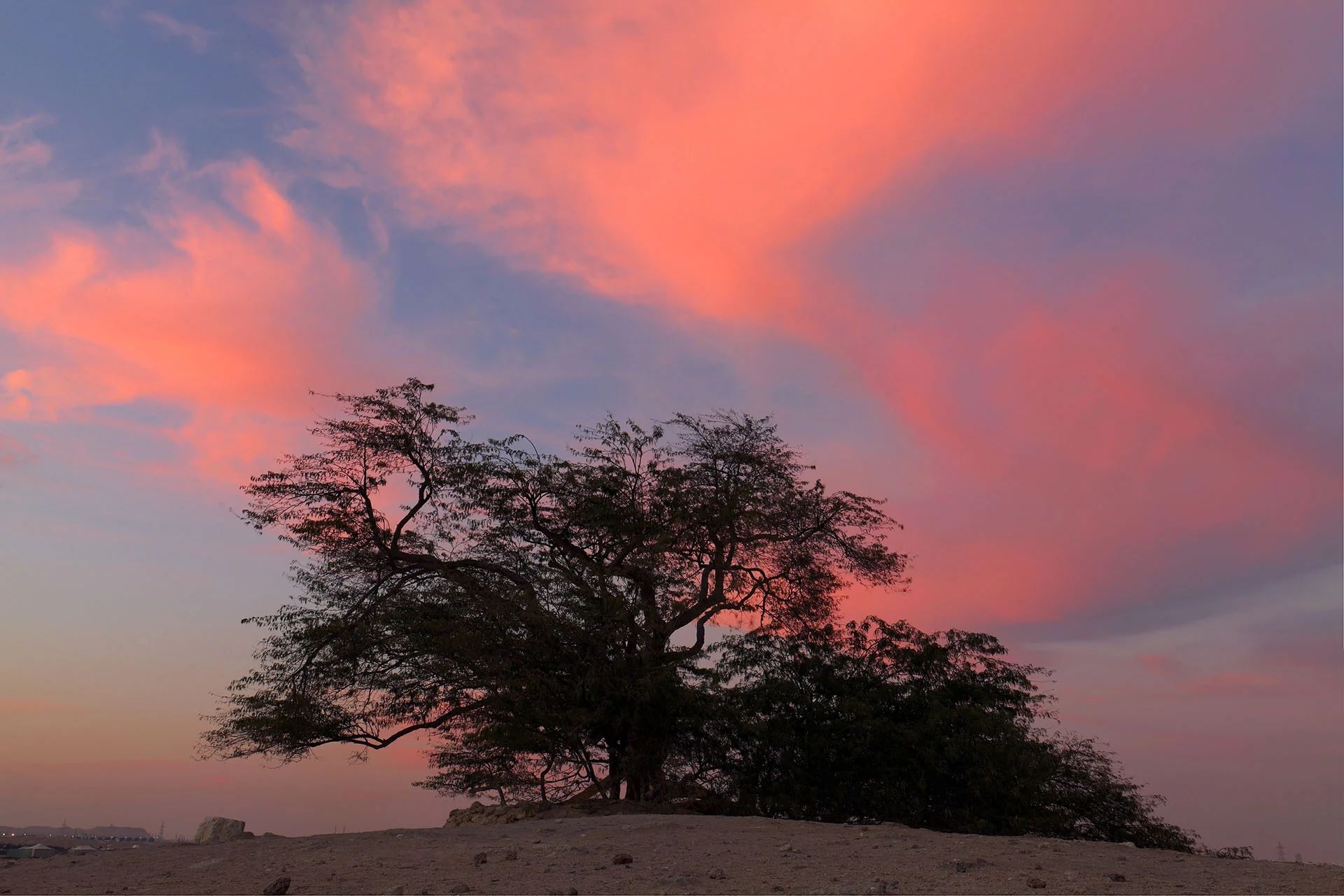
Bahrain’s most famous tree, the Sharajat-al-Hayat or ‘Tree of LIfe’ has stood alone in a brutally harsh climate for over 400 years, in a remote desert location
Climate. The Zagros Mountains across Iran cause low-level winds to be directed toward Bahrain. Dust storms from Iraq and Saudi Arabia transported by northwesterly winds, locally called shamal wind, causing reduced visibility in the months of June and July. Summers are very hot. The seas around Bahrain are very shallow, heating up quickly in the summer to produce very high humidity, especially at night. Summer temperatures may reach up to 50 °C (122 °F). Rainfall in Bahrain is minimal and irregular. Precipitation mostly occurs in winter, with an average of 70.8mm of rainfall recorded annually.
Biodiversity. More than 330 species of birds were recorded in the Bahrain archipelago, 26 species of which breed in the country. Millions of migratory birds pass through the RSA in the winter and autumn months. One globally endangered species, Chlamydotis undulata, is a regular migrant in the autumn. The many islands and shallow seas of Bahrain are globally important for the breeding of the Socotra cormorant; up to 100,000 pairs of these birds were recorded over the Hawar Islands. Bahrain’s national bird is the bulbul while its national animal is the Arabian oryx. The national flower of Bahrain is the beloved Deena. Only 18 species of mammals are found in Bahrain, animals such as gazelles, desert rabbits and hedgehogs are common in the wild. Twenty-five species of amphibians and reptiles were recorded as well as 21 species of butterflies and 307 species of flora. The marine biotopes are diverse and include extensive sea grass beds and mudflats, patchy coral reefs as well as offshore islands. Sea grass beds are important foraging grounds for some threatened species such as dugongs and the green turtle. In 2003, Bahrain banned the capture of sea cows, marine turtles and dolphins within its territorial waters. The Hawar Islands Protected Area provides valuable feeding and breeding grounds for a variety of migratory seabirds, it is an internationally recognised site for bird migration. The breeding colony of Socotra cormorant on Hawar Islands is the largest in the world, and the dugongs foraging around the archipelago form the second-largest dugong aggregation after Australia. Source: Bahrain – Wikipedia
Islamic Republic of Iran
Geography. Iran has an area of 1,648,195 km2 (636,372 sq mi). It lies between latitudes 24° and 40° N, and longitudes 44° and 64° E. Iran consists of the Iranian Plateau, with the exception of the coasts of the Caspian Sea and Khuzestan. It is one of the world’s most mountainous countries, its landscape dominated by rugged mountain ranges that separate various basins or plateaux from one another. The populous western part is the most mountainous, with ranges such as the Caucasus, Zagros, and Alborz, the last containing Mount Damavand, Iran’s highest point at 5,610 m (18,406 ft), which is also the highest mountain in Asia west of the Hindu Kush.
The northern part of Iran is covered by the lush lowland Caspian Hyrcanian mixed forests, located near the southern shores of the Caspian Sea. The eastern part consists mostly of desert basins, such as the Kavir Desert, which is the country’s largest desert, and the Lut Desert, as well as some salt lakes. Iran had a 2019 Forest Landscape Integrity Index mean score of 7.67/10, ranking it 34th globally out of 172 countries. The only large plains are found along the coast of the Caspian Sea and at the northern end of the RSA, where the country borders the mouth of the Arvand river. Smaller, discontinuous plains are found along the remaining coast of the RSA, the Strait of Hormuz, and the Gulf of Oman.
Climate. Having 11 climates out of the world’s 13, Iran’s climate is diverse, ranging from arid and semi-arid, to subtropical along the Caspian coast and the northern forests. On the northern edge of the country (the Caspian coastal plain), temperatures rarely fall below freezing and the area remains humid for the rest of the year. Summer temperatures rarely exceed 29 °C (84.2 °F). Annual precipitation is 680 mm (26.8 in) in the eastern part of the plain and more than 1,700 mm (66.9 in) in the western part. To the west, settlements in the Zagros basin experience lower temperatures, severe winters with below zero average daily temperatures and heavy snowfall. The eastern and central basins are arid, with less than 200 mm (7.9 in) of rain, and have occasional deserts. Average summer temperatures rarely exceed 38 °C (100.4 °F). The coastal plains of the RSA and Gulf of Oman in southern Iran have mild winters, and very humid and hot summers. The annual precipitation ranges from 135 to 355 mm (5.3 to 14.0 in).
Wildlife. The wildlife of Iran includes bears, the Eurasian lynx, foxes, gazelles, gray wolves, jackals, panthers, and wild pigs. Domestic animals include Asian water buffaloes, camels, cattle, donkeys, goats, horses, and sheep. Eagles, falcons, partridges, pheasants, and storks are also native to Iran. One of the most famous species of animal is the critically endangered Asiatic cheetah, also known as the Iranian cheetah. The Persian leopard, which is the world’s largest leopard subspecies and lives primarily in northern Iran, is endangered. Iran lost all its Asiatic lions and the now extinct Caspian tigers by the earlier part of the 20th century. Source: Wikipedia
Republic of Iraq
Geography. Iraq has a coastline measuring 58 km (36 miles) on the northern RSA and encompasses the Mesopotamian Alluvial Plain, the northwestern end of the Zagros mountain range and the eastern part of the Syrian Desert. Two major rivers, the Tigris and Euphrates, run south through Iraq and into the Shatt al-Arab near the RSA. Near the two major rivers are fertile alluvial plains, as the rivers carry about 60,000,000 m3 of silt annually to the delta. Rocky deserts cover about 40 percent of the land. Much of the south is marshy and damp. Another 30 percent is mountainous with bitterly cold winters. The north of the country is mostly composed of mountains; the highest point being at 3,611 m (11,847 ft) known locally as Cheekah Dar (black tent). Close to the coast and along the Shatt al-Arab (known as arvandrūd: اروندرود among Iranians) are marshlands.
Korsh Ararat
Iraq is home to seven terrestrial ecoregions: Zagros Mountains forest steppe, Syrian xeric grasslands and shrublands, Tigris-Euphrates alluvial salt marsh, Eastern Mediterranean conifer-sclerophyllous-broadleaf forests, Arabian Desert, Mesopotamian shrub desert, and South Iran Nubo-Sindian desert and semi-desert.
Climate. Much of Iraq has a hot arid climate with subtropical influence. Summer temperatures average above 40 °C (104 °F) for most of the country and frequently exceed 48 °C (118.4 °F). Winter temperatures infrequently exceed 21 °C (69.8 °F) with maxima roughly 15 to 19 °C (59.0 to 66.2 °F) and night-time lows 2 to 5 °C (35.6 to 41.0 °F). Typically, precipitation is low; most places receive less than 250 mm (9.8 in) annually, with maximum rainfall occurring during the winter months. Rainfall during the summer is rare, except in northern parts of the country. The northern mountainous regions have cold winters with occasional heavy snows, sometimes causing extensive flooding.
Biodiversity. Iraq has multiple biomes which include the mountainous region in north to the wet marshlands along the Euphrates river. The western part of the country comprises mainly desert and some semi-arid regions. As of 2001, seven of Iraq’s mammal species and 12 of its bird species are endangered. The endangered species include the northern bald ibis and Persian fallow deer. The Syrian wild ass is extinct, and the Saudi Arabian dorcas gazelle was declared extinct in 2008. The marshes are home to 40 species of birds, and several species of fish, plus demarcating a range limit for a number of bird species. The marshes were once home to millions of birds and the stopover for millions of migratory birds, including flamingo, pelican and heron as they migrated from Siberia to Africa. Seven species are now extinct or near extinction from the marshes, including the Indian crested porcupine, the bandicoot rat and the marsh gray wolf. The draining of the marshes caused a significant decline in bioproductivity. Iraqi coastal waters boast a living coral reef, covering an area of 28 km2 in the RSA, at the mouth of the Shatt al-Arab river. The coral reef was discovered by joint Iraqi–German expeditions of scientific scuba divers carried out in September 2012 and in May 2013. Prior to its discovery, it was believed that Iraq lacks coral reefs as the local turbid waters prevented the detection of the potential presence of local coral reefs. Iraqi corals were found to be adapted to one of the most extreme coral-bearing environments in the world, as the seawater temperature in this area ranges between 14 and 34 °C. The reef harbours several living stone corals, octocorals, ophiuroids and bivalves. There are also silica-containing demosponges. source: Iraq – Wikipedia
State of Kuwait
Geography. Located in the north-east corner of the Arabian Peninsula, Kuwait is one of the smallest countries in the world in terms of land area. Kuwait lies between latitudes 28° and 31° N, and longitudes 46° and 49° E. Kuwait is generally low-lying, with the highest point being 306 m (1,004 ft) above sea level. Mutla Ridge is the highest point in Kuwait.
Kuwait has ten islands. With an area of 860 km2 (330 sq. mi), the Bubiyan is the largest island in Kuwait and is connected to the rest of the country by a 2,380-metre-long (7,808 ft) bridge. 0.6% of Kuwaiti land area is considered arable with sparse vegetation found along its 499-kilometre-long (310 mi) coastline. Kuwait City is located on Kuwait Bay, a natural deep-water harbor.
Jahra Nature Reserve
During the 1991 Kuwaiti oil fires, more than 500 oil lakes were created covering a combined surface area of about 35.7 km2 (13+3⁄4 sq mi). The resulting soil contamination due to oil and soot accumulation had made eastern and south-eastern parts of Kuwait uninhabitable. Sand and oil residue had reduced large parts of the Kuwaiti desert to semi-asphalt surfaces. The oil spills during the Gulf War also drastically affected Kuwait’s marine resources.
Climate. Due to Kuwait’s proximity to Iraq and Iran, the winter season in Kuwait is colder than other coastal countries in the Arabian Peninsula (especially UAE, Qatar, and Bahrain). Kuwait is also less humid than other coastal regions in the Arabian Peninsula. The spring season in March is warm with occasional thunderstorms. The frequent winds from the northwest are cold in winter and hot in summer. Southeasterly damp winds spring up between July and October. Hot and dry south winds prevail in spring and early summer. The shamal, a northwesterly wind common during June and July, causes dramatic sandstorms. Summers in Kuwait are some of the hottest on earth. The highest recorded temperature was 54 °C (129 °F) at Mitribah on 21 July 2016, which is the highest temperature recorded in Asia.
National Parks. At present, there are five protected areas in Kuwait recognized by the IUCN. In response to Kuwait becoming the 169th signatory of the Ramsar Convention, Bubiyan Island’s Mubarak al-Kabeer reserve was designated as the country’s first Wetland of International Importance. The 50,948 hectare reserve consists of small lagoons and shallow salt marshes and is important as a stop-over for migrating birds on two migration routes. The reserve is home to the world’s largest breeding colony of crab-plover.
Biodiversity. Currently, 444 species of birds have been recorded in Kuwait, 18 species of which breed in the country. Kuwait is situated at the crossroads of several major bird migration routes and between two and three million birds pass each year. The marshes in northern Kuwait and Jahra have become increasingly important as a refuge for passage migrants. Kuwaiti islands are important breeding areas for four species of tern and the socotra cormorant. Kuwait’s marine and littoral ecosystems contain the bulk of the country’s biodiversity heritage. Twenty eight species of mammal are found in Kuwait; animals such as gerboa, desert rabbits and hedgehogs are common in the desert. Large carnivores, such as the wolf, caracal and jackal, are not found. Among the endangered mammalian species are the red fox and wild cat. Causes for wildlife extinction are habitat destruction and extensive unregulated hunting. Forty reptile species have been recorded although none are endemic to Kuwait. Source: Kuwait – Wikipedia
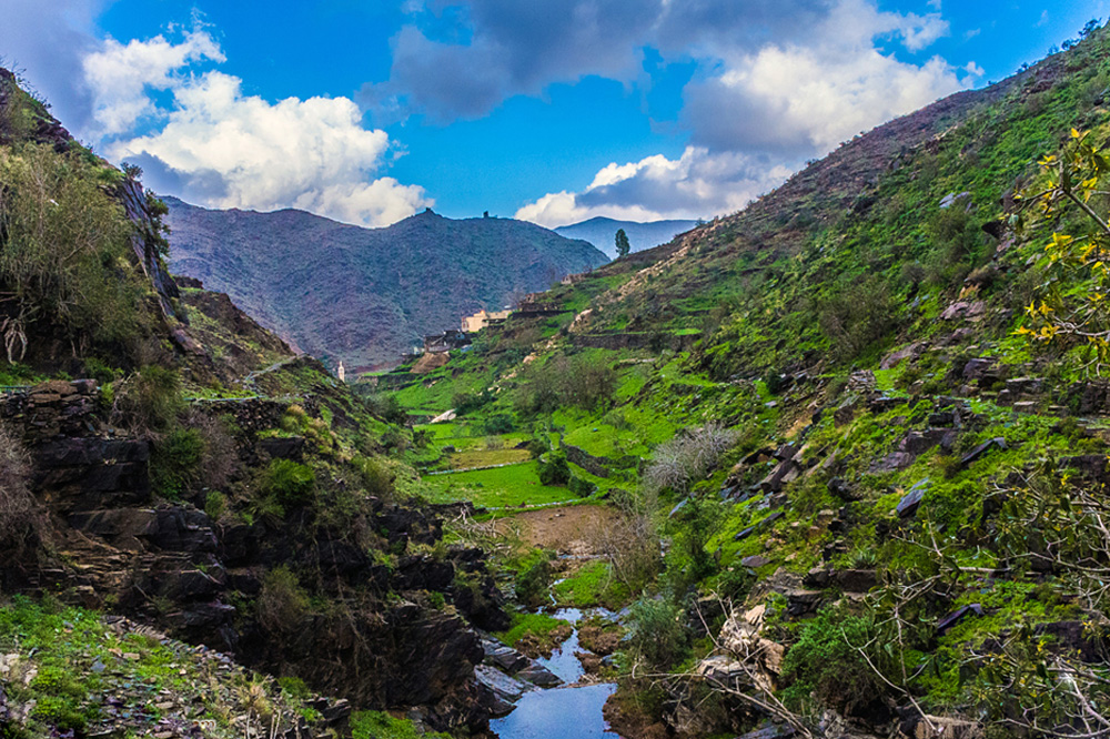
Sultanate of Oman
Geography. Oman covers an area of 309,500 km², it offers a variety of topographical features. There are valleys between rugged mountain ranges with terraced orchards where pomegranates, apricots, and roses grow, and extensive stretches of a vast plain with gravel desert interspersed with wadis and large pools of water in the middle. Oman’s main cities line up neatly along the coast.
Oman lies between latitudes 16° and 28° N, and longitudes 52° and 60° E. A vast gravel desert plain covers most of central Oman, with mountain ranges along the north (Al Hajar Mountains) and southeast coast (Qara or Dhofar Mountains), where the country’s main cities are located: the capital city Muscat, Sohar and Sur in the north, and Salalah in the south and Musandam.
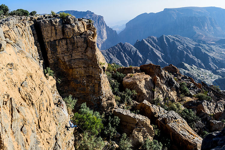
Jebel Akhdar Mountain
Climate. Oman’s climate is hot and dry in the interior and humid along the coast. During past epochs, Oman was covered by ocean, as evidenced by the large numbers of fossilized shells found in areas of the desert away from the modern coastline.
Oman generally has one of the hottest climates in the world—with summer temperatures in Muscat and northern Oman averaging 30 to 40 °C (86.0 to 104.0 °F). Oman receives little rainfall, with annual rainfall in Muscat averaging 100 mm (3.9 in), occurring mostly in January. In the south, the Dhofar Mountains area near Salalah has a tropical-like climate and receives seasonal rainfall from late June to late September as a result of monsoon winds from the Indian Ocean, leaving the summer air saturated with cool moisture and heavy fog. Summer temperatures in Salalah range from 20 to 30 °C (68.0 to 86.0 °F)—relatively cool compared to northern Oman.
The mountain areas receive more rainfall, and annual rainfall on the higher parts of the Jabal Akhdar probably exceeds 400 mm (15.7 in). Low temperatures in the mountainous areas leads to snow cover once every few years. Some parts of the coast, particularly near the island of Masirah, sometimes receive no rain at all within the course of a year.
Biodiversity. Desert shrub and desert grass, common to southern Arabia, are found in Oman, but vegetation is sparse in the interior plateau, which is largely gravel desert. The greater monsoon rainfall in Dhofar and the mountains makes the growth there more luxuriant during summer; coconut palms grow plentifully on the coastal plains of Dhofar and frankincense is produced in the hills, with abundant oleander and varieties of acacia. The Al Hajar Mountains are a distinct ecoregion, the highest points in eastern Arabia with wildlife including the Arabian tahr.
Indigenous mammals include the leopard, hyena, fox, wolf, hare, oryx and ibex. Birds include the vulture, eagle, stork, bustard, Arabian partridge, bee eater, falcon and sunbird. In 2001, Oman had nine endangered species of mammals, five endangered types of birds, and nineteen threatened plant species. Decrees have been passed to protect endangered species, including the Arabian leopard, Arabian oryx, mountain gazelle, goitered gazelle, Arabian tahr, green sea turtle, hawksbill turtle and olive ridley turtle.
source: Oman – Wikipedia
State of Qatar
Geography. The Qatari peninsula protrudes 160 kilometres (100 mi) into the RSA, north of Saudi Arabia. It lies between latitudes 24° and 27° N, and longitudes 50° and 52° E. Most of the country consists of a low, barren plain, covered with sand. To the southeast lies the Khor al Adaid (“Inland Sea”), an area of rolling sand dunes surrounding an inlet of the RSA. There are mild winters and very hot, humid summers.
The highest point in Qatar is Qurayn Abu al Bawl at 103 metres (338 ft) in the Jebel Dukhan to the west, a range of low limestone outcroppings running north–south from Zikrit through Umm Bab to the southern border. The Jebel Dukhan area also contains Qatar’s main onshore oil deposits, while the natural gas fields lie offshore, to the northwest of the peninsula.
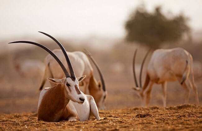
Oryx – the national animal of Qatar
Geography. The Qatari peninsula protrudes 160 kilometres (100 mi) into the RSA, north of Saudi Arabia. It lies between latitudes 24° and 27° N, and longitudes 50° and 52° E. Most of the country consists of a low, barren plain, covered with sand. To the southeast lies the Khor al Adaid (“Inland Sea”), an area of rolling sand dunes surrounding an inlet of the RSA. There are mild winters and very hot, humid summers.
The highest point in Qatar is Qurayn Abu al Bawl at 103 metres (338 ft) in the Jebel Dukhan to the west, a range of low limestone outcroppings running north–south from Zikrit through Umm Bab to the southern border. The Jebel Dukhan area also contains Qatar’s main onshore oil deposits, while the natural gas fields lie offshore, to the northwest of the peninsula.
Biodiversity & Wildlife. Qatar signed the Rio Convention on Biological Diversity on 11 June 1992, and became a party to the convention on 21 August 1996. A total of 142 fungal species have been recorded from Qatar. A book recently produced by the Ministry of Environment documents the lizards known or believed to occur in Qatar, based on surveys conducted by an international team of scientists and other collaborators.[Qatar – Wikipedia]
The wildlife of Qatar includes the peninsula’s flora and fauna and their natural habitats. The country’s terrestrial wildlife includes numerous small nocturnal mammals, a number of reptiles which mainly consist of lizard species, and arthropods. Aquatic animals primarily include fish, shrimp and pearl oysters. The desert and the shoreline form an important resting site for a number of migratory bird species during autumn and spring. Urban and agricultural developments have led to an increase in bird species. [Wildlife of Qatar – Wikipedia]
Kingdom of Saudi Arabia
Geography. Saudi Arabia occupies about 80 per cent of the Arabian Peninsula (the world’s largest peninsula), lying between latitudes 16° and 33° N, and longitudes 34° and 56° E. Because the country’s southern borders with the United Arab Emirates and Oman are not precisely marked, the exact size of the country is undefined. The United Nations Statistics Division estimates 2,149,690 km2 (830,000 sq mi) and lists Saudi Arabia as the world’s 12th largest state. It is geographically the largest country in the Middle East and the Arabian Plate.
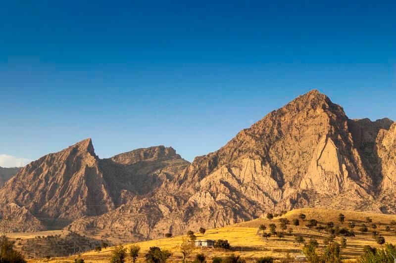
Shada Mountains
Saudi Arabia’s diverse geography is dominated by the Arabian Desert, associated semi-desert, shrubland, steppes, several mountain ranges, volcanic lava fields and highlands. The 647,500 km2 (250,001 sq mi) Rub’ al Khali (“Empty Quarter”) in the southeastern part of the country is the world’s largest contiguous sand desert. Though there are lakes in the country, Saudi Arabia is the largest country in the world by area with no permanent rivers. Wadis, non-permanent rivers, however, are very numerous. The fertile areas are to be found in the alluvial deposits in wadis, basins, and oases. The main topographical feature is the central plateau which rises abruptly from the Red Sea and gradually descends into the Nejd and toward the Gulf. Saudi Arabia is home to more than 2000 dormant volcanoes. Lava fields in Hejaz, known locally by their Arabic name of harrat (the singular is harrah), form one of Earth’s largest alkali basalt regions, covering some 180,000 square kilometres (69,000 sq mi).
Climate. Except for the southwestern regions such as Asir, Saudi Arabia has a desert climate with very high day-time temperatures during the summer and a sharp temperature drop at night. Average summer temperatures are around 45 °C (113 °F), but can be as high as 54 °C (129 °F) at its most extreme. In the winter the temperature rarely drops below 0 °C (32 °F) with the exception of mostly the northern regions of the country where annual snowfall, in particular in the mountainous regions of Tabuk province, is not uncommon. The lowest recorded temperature to date, −12.0 °C (10.4 °F), was measured in Turaif.
In the spring and autumn the heat is temperate, temperatures average around 29 °C (84 °F). Annual rainfall is very low. The Southern regions differ in that they are influenced by the Indian Ocean monsoons, usually occurring between October and March. An average of 300 mm (12 in) of rainfall occurs during this period, which is about 60 per cent of the annual precipitation. Saudi Arabia is home to approximately 1300 islands.
Biodiversity. Saudi Arabia is home to five terrestrial ecoregions: Arabian Peninsula coastal fog desert, Southwestern Arabian foothills savanna, Southwestern Arabian montane woodlands, Arabian Desert, and Red Sea Nubo-Sindian tropical desert and semi-desert. Wildlife includes the Arabian leopard, wolf, striped hyena, mongoose, baboon, hare, sand cat, and jerboa. Animals such as gazelles, oryx, leopards and cheetahs were relatively numerous until the 19th century, when extensive hunting reduced these animals almost to extinction. Birds include falcons (which are caught and trained for hunting), eagles, hawks, vultures, sandgrouse, and bulbuls. There are several species of snakes, many of which are venomous. Saudi Arabia is home to a rich marine life. The Red Sea in particular is a rich and diverse ecosystem. More than 1200 species of fish have been recorded in the Red Sea, and around 10 per cent of these are found nowhere else.
The rich diversity is in part due to the 2,000 km (1,240 mi) of coral reef extending along its coastline; these fringing reefs are 5000–7000 years old and are largely formed of stony acropora and porites corals. These coastal reefs are also visited by pelagic species of Red Sea fish, including some of the 44 species of shark. The Red Sea also contains many offshore reefs including several true atolls. Many of the unusual offshore reef formations defy classic (i.e., Darwinian) coral reef classification schemes, and are generally attributed to the high levels of tectonic activity that characterize the area. Domesticated animals include the legendary Arabian horse, Arabian camel, sheep, goats, cows, donkeys, chickens, etc. Reflecting the country’s dominant desert conditions, Saudi Arabia’s plant life mostly consists of herbs, plants, and shrubs that require little water. The date palm (Phoenix dactylifera) is widespread.
Source: [Saudi Arabia – Wikipedia]
United Arab Emirates
Geography. The UAE lies between 22° 30′ and 26° 10′ north latitude and between 51° and 56° 25′ east longitude. It shares a 530-kilometre (330 mi) border with Saudi Arabia on the west, south, and southeast, and a 450-kilometre (280 mi) border with Oman on the southeast and northeast. The land border with Qatar in the Khawr al Udayd area is about nineteen kilometres (12 miles) in the northwest; The largest emirate, Abu Dhabi, accounts for 87% of the UAE’s total area (67,340 square kilometres (26,000 sq mi)). The smallest emirate, Ajman, encompasses only 259 km2 (100 sq mi).
Roads leading to Jebel Jais, the highest mountain in the UAE (1,892 m), in Ras Al Khaimah. South and west of Abu Dhabi, vast, rolling sand dunes merge into the Rub al-Khali (Empty Quarter) of Saudi Arabia. The desert area of Abu Dhabi includes two important oases with adequate underground water for permanent settlements and cultivation. The extensive Liwa Oasis is in the south near the undefined border with Saudi Arabia. About 100 km (62 mi) to the northeast of Liwa is the Al-Buraimi oasis, which extends on both sides of the Abu Dhabi-Oman border. [United Arab Emirates – Wikipedia]
Climate. The climate of the UAE is subtropical-arid with hot summers and warm winters. The climate is categorized as desert climate. The hottest months are July and August, when average maximum temperatures reach above 45 °C (113 °F) on the coastal plain. In the Al Hajar Mountains, temperatures are considerably lower, a result of increased elevation. Average minimum temperatures in January and February are between 10 and 14 °C (50 and 57 °F). During the late summer months, a humid southeastern wind known as Sharqi (i.e. “Easterner”) makes the coastal region especially unpleasant. The average annual rainfall in the coastal area is less than 120 mm (4.7 in), but in some mountainous areas annual rainfall often reaches 350 mm (13.8 in). Rain in the coastal region falls in short, torrential bursts during the winter months, sometimes resulting in floods in ordinarily dry wadi beds. The region is prone to occasional, violent dust storms, which can severely reduce visibility. [United Arab Emirates – Wikipedia]
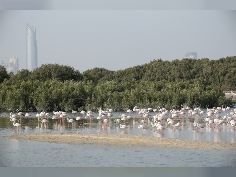
Biodiversity. The UAE has a relatively rich biological diversity that includes a range of ecosystems and terrestrial and aquatic habitats. Many species are characterised by their unique adaptation to the UAE environment and special climate conditions. Accordingly, the UAE has taken several measures to conserve biodiversity while many studies have been carried out on species and habitats, most notably the study of large flamingos and raptors, surveys of vertebrates, the study of non-indigenous species and field surveys.
The UAE has also established natural protected areas, the number which increased from 19 in 2010 to 43 in 2016, occupying 14.35 percent of UAE area, a total of 18,000 sq. kilometers.
The wildlife of the United Arab Emirates is the flora and fauna of the country on the eastern side of the Arabian Peninsula and the southern end of the Gulf (RSA). The country offers a variety of habitats for wildlife including the coast, offshore islands, mangrove areas, mudflats, salt pans, sand and gravel plains, sand dunes, mountain slopes, wadis and rocky summits. Because the terrain is so varied, it supports a greater number of species of plants and animals than might have been expected in this relatively small country. [Wildlife of the United Arab Emirates – Wikipedia]