The ROPME Sea Area
The ROPME Sea Area (originally referred to as the Kuwait Action Plan Region) is the sea area surrounded by the eight Member States of ROPME: Bahrain, I.R. Iran, Iraq, Kuwait, Oman, Qatar, Saudi Arabia and the United Arab Emirates. The term “ROPME Sea Area” was coined by Plenipotentiaries of the Member States to achieve unanimity in denoting the area covered by the Kuwait Regional Convention of 1978. It reflects the goodwill of the Member States to cooperate in protecting their common marine environment in spite of the existing geopolitical boundaries.
Several other legal instruments were developed and adopted by the Member States of ROPME as Regional Protocols in support of the Kuwait Regional Convention:
- Protocol concerning Regional Cooperation in Combating Pollution by Oil and other Harmful Substances in Cases of Emergency (ROPME, 1978b)
- Protocol concerning Marine Pollution resulting from Exploration and Exploitation of the Continental Shelf (ROPME,1989) from Land-Based Sources (ROPME, 1990)
- Protocol for the Protection of the Marine Environment against Pollution
- Protocol on the Control of Marine Trans-boundary Movements and Disposal of Hazardous Wastes and Other Wastes (ROPME, 1998)
- Protocol concerning the Conservation of Biological Diversity and the Establishment of Protected Areas
Legal Boundaries
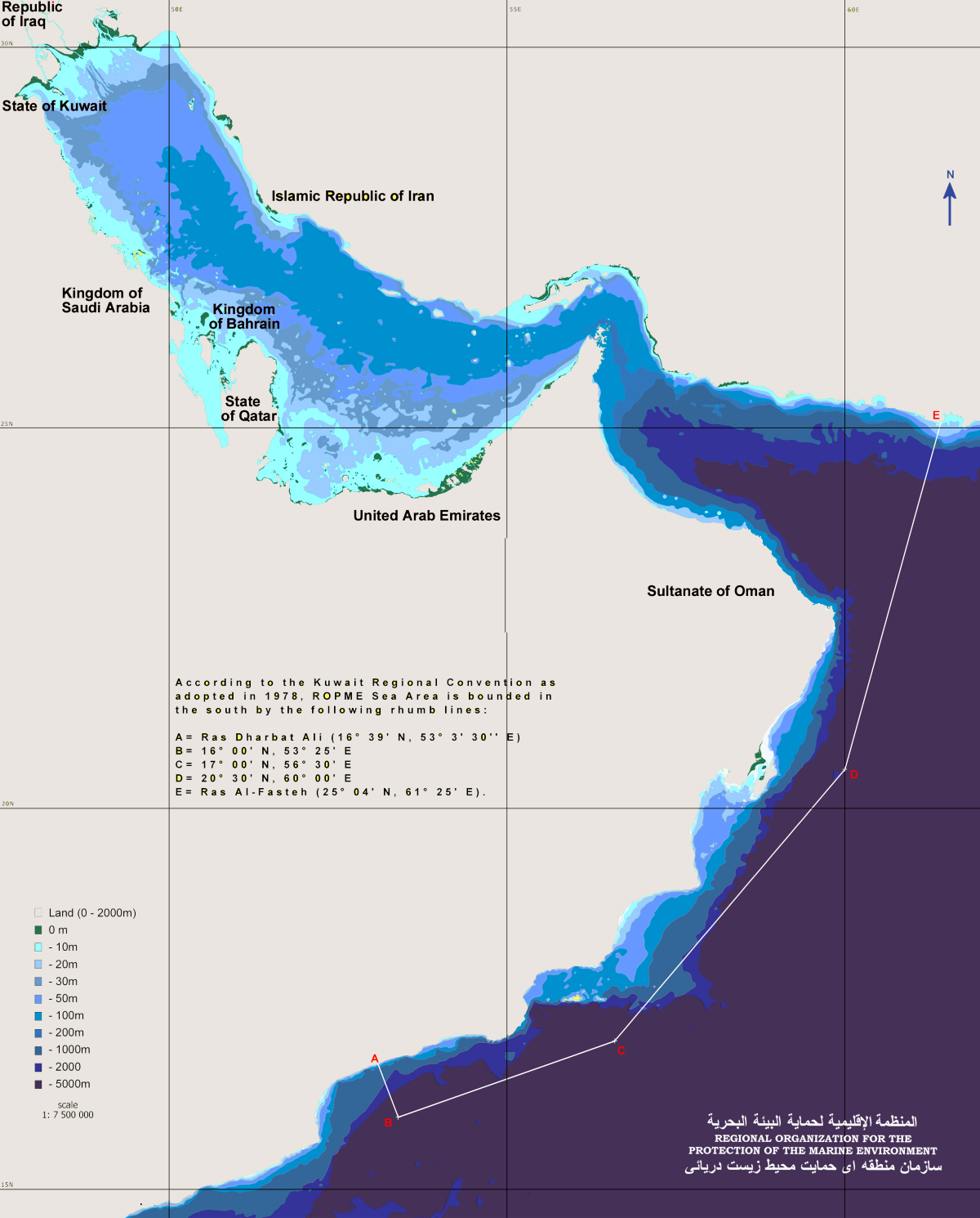
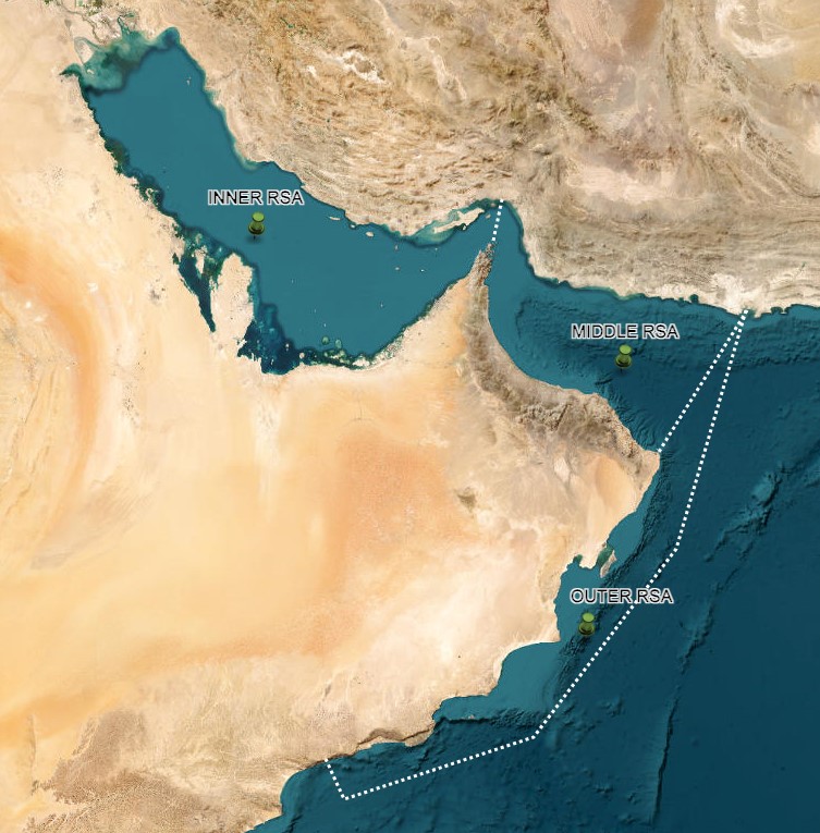
The RSA is bounded in the south by the rhumb lines 16° 39′ N, 53° 3′ 30′ E; 16° 00′ N, 53° 25′ E; 17° 00′ N, 56° 30′ E; 20° 30′ N, 60° 00′ E; 25° 04′ N, 61° 25′ E, adding up approximately to a surface area of 465,000 km² comprising three geographically and environmentally distinct parts: the Inner RSA (I-RSA), the Middle RSA (M-RSA) and the Outer RSA (O-RSA) as described above.
Article II of the Convention defines the boundaries of the ROPME Sea Area (RSA), as shown in image above . Furthermore, the continuous effort of ROPME/MEMAC succeeded in declaring the sea area located northwest of the rhumb line between Ras Al-Hadd (22° 30′ N, 60° 00′ E) and Ras Al-Fasteh (25° 04′ N, 61° 25′ E) as a “Special Area” by the International Maritime Organization (IMO) on 1st August 2008.
The RSA is further divided into three geographically and environmentally distinct parts. The division referred to as the Inner RSA (I-RSA) consists of the marine area west of 56°E longitude that extends along the NW/SE axis from the north boundary of the RSA to the north of Strait of Hormuz. The Middle RSA (M-RSA) covers the Sea of Oman, and the Outer RSA (O-RSA) stretches over the entire southern boundary of the RSA across the Arabian Sea that starts from Ra’s Al-Hadd to the southern border of Oman.
Physical Characteristics of the RSA
The ROPME Sea Area (RSA) can be divided into three distinct zones, the Inner, Middle and Outer ROPME Sea Area, which vary in terms of their physical characteristics and vulnerability to climate change impacts.
THE INNER ROPME SEA AREA is a shallow, semi enclosed sea with an average depth of 38 m. The profile of the seafloor across the Inner RSA is asymmetrical, with shallower slopes on the southwest shore and steeper slopes alongside the coast of Iran. Sea surface temperature and salinity vary significantly by location and season. Average sea surface temperatures range from 13 to 35°C and salinity from 36 to 70 practical salinity units.
THE MIDDLE ROPME SEA AREA is a deep sea that extends for almost 400 km and connects the Indian Ocean with the Inner ROPME Sea Area through the shallow and narrow Strait of Hormuz. It is partially affected by the northern Indian Ocean monsoons, but the effect diminishes with increasing distance from the Indian Ocean. Average sea surface temperatures range from 22 to 32°C.
THE OUTER ROPME SEA AREA is in the northern part of the Indian Ocean and has a monsoonal climate. The summer monsoon (June to September) produces strong seasonal upwelling events along the southeast coast of the Arabian Peninsula. Average sea surface temperatures range from 22 to 26°C. Water depth reaches more than 1000m on the oceanic fringe of the Outer RSA.
Contents
Bathymetry
The bathymetry of the RSA varies considerably over its three different parts. The I–RSA is a sedimentary basin, shaped to a great extent by a Tertiary fold system, which causes its deepest depression to run along its northern side (Sheppard et al., 1992). It is asymmetric, with its northwest southeast axis separates a stable and very gradually sloping Arabian shoreline on one side from a geologically unstable and steeper Asian or Iranian shoreline (Purser and Seibold, 1973). No part of the I–RSA has a continental shelf edge and there are no large or abrupt changes in bathymetry, except at the entrance to the M–RSA in the east. Today the I–RSA is a basin which is relatively shallow sea with a depth ranging between 10–100 m which means almost all parts of it lie within the photic zone (Al-Ghadban and Abdali, 1998).
The deepest region being closest to the Iranian coast, with its bottom slopes gradually from the very shallow deltaic northern part to deeper waters in the south, where it reaches more than 100 m at the entrance of the Straits of Hormuz. There is no silt in the Strait of Hormuz; the trough simply deepens to more than 100 m through the Strait and drops quickly to more than 2000 m within 200 km outside the Strait (Reynolds, 1993), in the M-RSA. The basin of the M-RSA (Sea of Oman) widens and gets deeper towards the Arabian Sea, reaching depths exceeding 5000 m in the O-RSA. > Back
Sea Temperature
An analysis of sea surface temperature (SST) for the period 1982–2015 covering the Inner RSA and Middle RSA identified overall warming of around 1ºC, with shallower areas warming faster than deeper waters. In the Outer RSA, occasional surveys during the summer monsoon season suggest a similar temperature increase has occurred.
Climate models indicate that future SST increases in the Inner RSA will be higher than for the Middle and Outer Regions. Under a high-emissions scenario, SST could increase by 2.8–4.3°C in the Inner RSA, compared to around 2.5°C in the Middle RSA and Outer RSA, by end of century. Warming is expected to be greatest during the summer season. > Back
Sea Level
There are few long time series of sea-level change in the RSA, and those that exist are restricted to the Inner RSA. Based on seven tide gauge records in the northwest of the Inner RSA, an average sea level rise of 2.2 mm per year has been estimated for the period 1979–2007.
For the Middle RSA and Outer RSA, estimates of change based on measurements in the wider Northern Indian Ocean are lower at around 1.29 mm per year over a similar period. Regional sea level rise projections for the RSA are very limited. The most recent estimates published by the IPCC in 2019 suggest a mean global increase of 0.84 m by the end of century under a high-emissions scenario. This is higher than previous IPCC estimates. > Back
Salinity
Salinity of surface waters in the Inner RSA has increased by 0.5–1.0% over the past 60 years, due to increased evaporation, progressive reductions in freshwater inputs and more locally, the influence of hypersaline discharges from desalination plants.
Under a high-emissions scenario, an increase in salinity is suggested for the Inner RSA. In the eastern Middle RSA near the Strait of Hormuz, salinity could also increase, whilst the Outer RSA may experience declines in salinity. > Back
Dissolved Oxygen
An oxygen minimum zone occurs between 200 and 1000m depth across the Outer RSA and Middle RSA. This is a permanent feature and is one of the most intense oxygen minimum zones in the world. Oxygen concentrations are projected to decline further.
Seasonal or transitory areas of low oxygen concentrations also occur in shallow coastal waters in the Inner RSA, and are expected to become larger and more persistent over the coming century, partly in response to climate change. > Back
Carbonate Chemistry and pH
Few pH measurements exist for the RSA, and where they do, the time period covered is too short to detect significant trends. In the Outer RSA where pH is affected by the seasonal upwelling, summer pH is as low as 7.93, compared to 8.05–8.09 during the winter months.
Repeat measurements from survey cruises in the Outer RSA suggest an overall decrease in average pH between 1960 and 2000. This decrease is approximately 0.1 pH units in the upper 50m and 0.2 pH units at 300m depth.
Recent global projections under a high emissions scenario suggest that pH in the RSA could decrease by approximately 0.25 units. > Back
Tropical Cyclones
Since 2007 there have been several tropical cyclones in the RSA. The strongest cyclones to make landfall in the RSA to date were Gonu and Phet. These coincided with periods of elevated SST in the Outer RSA.
One modelling study suggests that, under a high-emissions scenario, the number of tropical cyclones in the Outer and Middle RSA will increase by the end of this century and that some cyclones may reach the Inner RSA. > Back
Shamal Winds and Dust Storms
In the Inner RSA, Shamal winds, which can generate storms and surge events, and are also important for dust accumulation, appear to have increased since 2000. Dust storms have become more frequent and intense in the RSA with adverse consequences for air quality and public health. > Back
Biodiversity
The RSA is home to a diverse range of species including many of global conservation importance. This includes populations of turtles, rare seabirds, dugongs, dolphins and whales, which are supported by key habitats such as coral reefs, seagrasses and mangroves. These habitats also provide critical ecosystem services, such as storing carbon, protecting coastlines and supporting productive fisheries and a growing tourism sector.
Climate change can affect biodiversity in a number of ways, and these impacts can be exacerbated by other human pressures such as resource over-exploitation, pollution and habitat degradation associated with coastal development. > Back
Phytoplankton Productivity
Climate models indicate a decline in plankton productivity across the RSA over this century due to changes in water currents, nutrients and oxygen supply. A decline in plankton productivity would have negative impacts on the marine food chain, including fisheries.
The area influenced by tropical monsoon systems may increase over the 21st Century, changing the timing, strength, and direction of winds that control the upwelling of nutrient-rich waters in the Outer RSA. > Back
Harmful Algal Blooms (HABs)
HABs in the RSA are an important issue and their geographical scale and persistence appear to be increasing. For example, HABs have become more frequent in the Outer RSA in recent years. HABs can cause severe disruption and damage, including blocking cooling water intakes in coastal desalination and industrial plants, and causing large-scale mortality of fish and other marine organisms.
Currently, a link between occurrence of HABs and climate change in the RSA has not yet been fully established. > Back
Fish
Up to 10% of fish species occurring in the Inner RSA may become Regionally extinct by the end of the century as a result of increasing temperature and salinity. This is at least twice as high as predictions for other regions where similar assessments have been undertaken.
Productivity of important pelagic fish species such as tuna and sardine in the Middle and Outer RSA may decline due to an expansion of the oxygen minimum zone.
Following coral bleaching events, reef fish assemblages have been observed to change. As the coral dies there is a decline in the total number of fish species and the relative proportion of herbivorous fish species increase. > Back
Jellyfish Blooms
Jellyfish blooms are known to occur across the RSA, and outbreaks and aggregations are becoming more frequent. This has been partly attributed to increases in water temperature.
Jellyfish blooms can block intakes of desalination plants and cooling water systems in coastal industries. There are increasing reports of these events occurring across the RSA. > Back
Birds
There is growing evidence that extreme weather events, which could become more severe and/or frequent, can have adverse effects on populations of seabirds by disturbing their breeding habitats and creating unfavourable feeding conditions.
Wetlands in the RSA, which are important for coastal and migratory birds, are highly vulnerable to sea-level rise. This could have serious implications for bird populations that depend on them. > Back
Marine Mammals and Turtles
Turtle populations will be impacted as warmer temperatures can alter the sex ratio of hatchlings, and compromise their fitness. In addition, rising sea levels and storms could severely damage beach nesting grounds. Any localised declines in seagrass would reduce an important food source for some turtle species.
Projections of direct temperature impacts on dugongs are inconclusive, with some models showing that the Inner RSA will become less hospitable while others suggest no change overall. However, this does not take into account the potential loss of seagrass, the sole source of food for dugongs, due to climate change.
Dolphins and whales are more tolerant to changes in temperature and salinity compared to other species. Indirect climate impacts on their food sources, such as fish, are likely to be more significant in determining their abundance and distribution. > Back
Coral Reefs
There has been a rapid decline in coral reefs across most of the RSA in the last two decades. This has been linked to a wide range of climatic drivers as well as other human pressures. Repeated and widespread bleaching events have taken place across both the Inner and Middle RSA due to increasing summer water temperatures. This has led to mass mortality of most of the staghorn (Acropora) corals in these areas.
In the Inner RSA, corals are already experiencing extreme high temperatures that are not projected to occur until the end of century in other low-latitude regions. In future decades, most reefs in the Inner RSA will be under threat from the combined effects of warming, ocean acidification and other local stressors. However, some coral communities with reduced species diversity and physical complexity may be able to adapt and persist. > Back
Mangroves
Up to 96% of RSA coastal wetlands are threatened by a combination of sea-level rise, subsidence and physical constraints on landward migration due to coastal development (also known as ‘coastal squeeze’). This includes mangroves, which could be lost by the end of this century.
Projected increases in air temperature by the end of the century could reduce mangrove growth rates due to moisture limitation and temperatures exceeding their maximum tolerance.
Across the Region, reduced rainfall, higher evaporation and increasing salinity are likely to limit build-up of sediments. Sediment accretion is important for keeping pace with sea-level rise.
Storms and cyclones can cause severe damage to mangrove forests. If these become more frequent or intense, the trees may not have enough time to recover between severe events, leading to long-term degradation. > Back
Seagrass
Tropical seagrasses in the RSA can withstand periods of elevated temperatures but are adversely affected by prolonged exposure. Extended periods of sea temperatures above 40 degrees are lethal.
Any increase in the frequency and/or magnitude of storms and cyclone events would threaten seagrasses throughout the RSA, particularly those in intertidal and shallow locations, by subjecting meadows to persistent conditions of turbidity and siltation.
Seagrass productivity may be enhanced under elevated concentrations of carbon dioxide. This could provide a positive feedback, with seagrass beds buffering pH levels and creating local refugia for calcifying organisms within coastal zones. > Back
Rocky Shores and Marine Algae Communities
The easternmost point of the Arabian Peninsula, Ras Al Hadd, Oman, currently acts as a boundary for marine macroalgae (seaweeds), with distinctly different species in the Middle RSA compared to the Outer RSA. Distribution patterns, associated with differing temperature affinity of the species, could alter with future climate change.
Storms and cyclones can have serious impacts on rocky shores communities. A combination of strong wave action and sand scouring can cause severe physical damage along large stretches of coast. > Back